Simulate
We are simulating volcanic hazards to determine the likelihood of eruptions, ashfall, pyroclastic flow and tsunami, and impacts of these hazards on coastal communities.
We are modelling tsunami generation from island volcanic sources and assessing their ability to impact mainland New Zealand. To do this, we are extending New Zealand’s volcanic-sourced tsunami simulator (PELE). Using a specialised instrumented water pool, we will simulate hot pyroclastic flow and cold landslide flows into water to investigate how the resulting tsunamis form and differ in their characteristics.
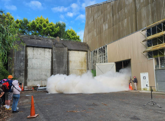
The below video captures a PELE experiment simulating how powerful pyroclastic flows from volcanoes could travel at high speeds across the water surface. Watch as the team set up and run this spectacular (but safely-contained) experiment and detail some interesting observations on how pyroclastic density currents behave above and below the water surface.
New data and understanding of mass flow-water dynamics from this physical simulator will inform the developments of newmodelling capabilities and computer-based simulation models. These computer-based simulation models (eg COMCOT), populated with geoscience data from the Explore Project, will be used to determine likelihood of tsunami occurring from mass failures on the volcanic islands and calculate tsunami wave height and inundations to develop detailed assessments of tsunami impacts on the North Island’s east coast.
To understand historic eruptions, we will examine seafloor sediments (collected in Explore) looking for ash layers from past eruptions to inform the likelihood of future eruptions, as well as search for evidence of past hazard events such as large-scale tsunami generating flank collapse. This work informs the long-term eruption possibilities for these near-shore volcanoes.
Simulating ash dispersal from eruptions of various magnitude is being used to assess the probability of ashfall across the Bay of Plenty and the greater North Island under different eruption scenarios in modern weather conditions.
Bayesian Networks will be developed to forecast unrest and eruptions from GeoNET monitoring data, as well as to provide a comprehensive assessment of the vulnerability of coastal communities to volcanic island hazards.
Header image credit: David Johnston