Geophysics Surveys

Geophysical survey methods investigate the physical properties of the deep to shallow crust. They let us see beneath the surface of the Earth, and measure properties of the deep underground to understand the conditions there and what might be happening.
Hyperspectral – airborne surveys
Hyperspectral imaging collects and processes information from across the electromagnetic spectrum, including invisible to the human eye. Hyperspectral mapping techniques can identify individual species of iron and clay minerals, which can provide detailed information about hydrothermal mineralisation and alteration zones.
Airborne hyperspectral data will map the surface alteration mineralogy of Whakaari, providing important guidance for interpretation of alteration from the magnetic and gravity data. Owing to its heavily vegetated nature, hyperspectral will not be flown at Tūhua.
SkyTEM – airborne electromagnetic surveys
Transient electromagnetic (TEM) is a commonly-used, non-intrusive, geophysical method for obtaining subsurface resistivity-conductivity data.
SkyTEM is a helicopter-born system that can measure to depths over 500m, allowing comprehensive interpretation of the near-surface geology (e.g. faults, cap rock, geothermal).
SkyTEM in action
Gravity & Magnetics – land-based surveys
Land-based gravity, magnetics and GPS data will be collected on both islands to map geological composition and the structure of the subsurface.
Gravity surveys measures variations in the Earth's gravitational field caused by differences in the density of sub-surface rocks.
Magnetic surveys look for variations in the magnetic properties of the underlying rocks.
Electromagnetic Surveys – magnetotellurics, on land and at sea
Magnetotellurics (MT) is a passive geophysical method that measures the natural variations in electrical conductivity (or its inverse, resistivity) in the Earth’s crust. Conductivity and resistivity are fundamental properties of materials. A low resistivity (high conductivity) means the material is a good conductor of electrical currents, and vice versa.
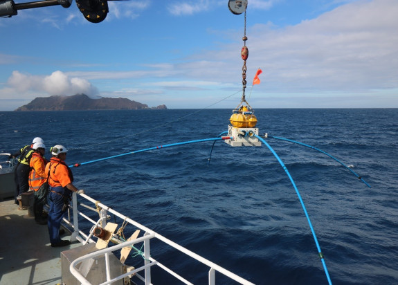
Marine MT Measurements: The Scripps Institute of Oceanography (SIO) is supplying and operating their array of marine-MT receivers, a completely autonomous seafloor data logging system.
Land-based MT Surveys: High- frequency MT stations on the islands, will complement the marine MT stations and provide important shallow information for hydrothermal system mapping.
Magnetotellurics Inversion: MT inversion will image the deep magma chambers and fluid and heat pathways that drive the hydrothermal systems, while heat flow measurements and gravity and magnetic inversions will define the shallower hydrothermal circulation that causes rock-weakening alteration.
Watch the MT being deployed